This new breed of satellite, to be launched early next year, will provide scientists with a tool to measure and manage the natural resources upon which mankind depends for his existence.

SOME time next year, the National Aeronautics and Space Administration will launch a satellite that will herald a new era in the practical utilization of aerospace technology. From the vantage point of a space orbit, the craft-called the Earth Resources Technology Satellite, or ERTS-will provide scientists with a powerful new tool with which to measure and manage the natural resources upon which mankind depends for his existence.
ERTS and its successors may provide capabilities to:
- Map the entire earth within a year or less
- Catalogue water resources
- Survey crops, forests, and other vegetation, revealing their vigor
- Detect water and air pollution and trace their sources
- Identify soil and rock types and collect data on their moisture content
- Acquire scientific oceanographic data and help commercial fishermen to find the most productive fishing grounds
- Find promising sources of minerals
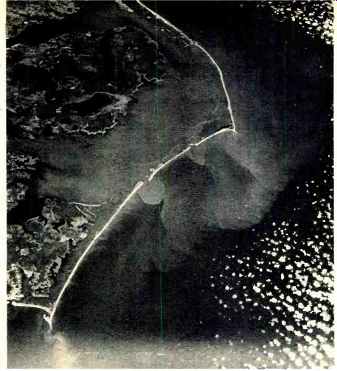
--------- A picture, originally in color, taken during an Apollo
mission shows current patterns and effluent discharge from Albermarle
and Pamlico Sounds located along the North Carolina coastline.
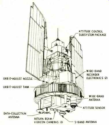
---- Some of the important components in the ERTS satellite.
These objectives, although ambitious, already have a basis in fact even though the first ERTS will not fly until 1972. Experiments conducted from aircraft and during manned space flights, as well as research and development programs in laboratories across the country, have demonstrated the efficacy of using earth-orbiting platforms to acquire data on the globe's natural resources.
Although it has been under study by both NASA and private industry for some time, the initial ERTS is just beginning to take shape. It will bear a close resemblance to the Nimbus experimental meteorological satellite which is being adapted by its builder, General Electric, for the earth resources mission. This approach is consonant with the philosophy evolved for ERTS by NASA's Goddard Space Flight Center during initial studies of the program. At that time, the planners concluded that it would be best to modify an existing spacecraft design rather than develop an entirely new satellite.
The primary sensors to be carried by each of the first two satellites in the series, ERTS A and B, will be three RCA return-beam vidicon TV cameras and a Hughes multispectral radiometric scanner. The satellite also will have a data collection /relay system and a pair of wide-band recorders to store data from TV cameras and scanner. The sensors will be aimed at earth continuously since ERTS will make one revolution per orbit as it flies a 565-mile-high polar path synchronized with the sun's movement.
The return-beam vidicon cameras will be the highest resolution TV cameras ever flown in space. They will employ 4200 horizontal scanning lines as contrasted with about 1000 lines for the previous highest resolution space TV and 525 lines for commercial TV in the United States. The three cameras will view the same 100-by-100 mile ground area.
However, each will image the scene in a different portion of the light spectrum: one in green (0.47-0.61 micron), a second in red (0.59-0.71 micron), and a third in the near-infrared (0.68-0.89 micron) region.
The multispectral scanner will view a 100-mile swath with the vertical component of the image being provided by the satellite's motion. It will employ bands close to those of the TV- 0.5-0.6, 0.6-0.7, and 0.7-0.8 micron-plus an additional channel that goes farther into the infrared region at 0.8-1.2 microns. In addition, the ERTS B scanner will have a fifth band still farther into the infrared region, covering 10.4-12.6 microns.
The "slicing" of the light spectrum into separate spectral bands will be the key to the satellite's data-producing capabilities. The separate images, after receipt and processing on the ground, can be combined into one special view in which ground features are more pronounced than in conventional photography. The individual separations also will be valuable in themselves since certain earth resources information is revealed best in specific spectral bands. Surface water is best seen in the near-infrared band, while the green band is useful for seeing through water to survey shoaling in the near-coastal regions.
Photography of the earth from space using spectral bands similar to those slated for ERTS A and B has been accomplished during the Apollo program. During the Apollo 9 mission, the astronauts mounted film cameras in a spacecraft window and photographed the ground below. The resulting data was used to verify the bands selected for ERTS. In addition to its TV and scanner, the satellite will carry a system for receiving, storing, and then transmitting to ground stations data from a wide variety of ground-based sensors, such as stream-flow gages or soil-moisture monitors. The spacecraft thus can serve as a communications link to a host of widely scattered remote sensors.
Ground stations at Greenbelt, Maryland, Corpus Christi, Texas, and Fairbanks, Alaska, will put a receiving site within range of the satellite any time it is over the United States or its adjacent coastal areas. When the spacecraft is out of range of a station, data from the TV and scanner will be stored on a new wide-band recorder under development by RCA. The recorder is taking aim on a new standard of reliability and long life in space. It will be designed to operate for 1000 hours, or about three times as long as any previous similar system. The recorders (two will be carried in each satellite for redundancy) will record TV-camera signals from d.c. to 4 MHz and 15 megabit-per-second digital data from the scanner. However, while it can record data from both, the recorder cannot accept inputs from the TV and scanner simultaneously; it must record from one or the other . The output of ERTS, therefore, will be high-resolution images in various segments of the light spectrum plus the data it will receive and relay from the ground-based remote sensors. Analyzed on the ground with the aid of computers and other interpretive techniques, the satellite is expected to give scientists their first opportunity to take a comprehensive, up-to-date look at the condition of the entire earth-and do it repetitively on a timely basis since the satellite will cover any given 100-by-100 mile area each 17-18 days.
Benefits from the Satellite One of the first and surest beneficiaries of ERTS will be cartography. Because it is taken from so high above the earth, the data in a satellite picture is orthographic. Subjects within the scene maintain their proper spatial relationships so the image need not be subjected to elaborate and expensive processing to remove distortions, as is required with photographs taken from aircraft. A satellite photograph, therefore, becomes an "instant map." Also, everything pertinent is shown at the scale for which the taking cameras are configured so no one must decide what to include or exclude as is the case with maps drawn by draftsmen. The presentation is objective.
Another, and enormous, cartographic advantage stems from the satellite's speed and sun-synchronous orbit. It will always view the ground below at the same sun angle and therefore lighting of the scene will be uniform. Aircraft, on the other hand, are constantly subjected to changing sun angles over even just a few hours of aerial mapping. The result is non-uniform lighting in the separate photographs that are mosaiced to form an aerial map. The shadowing causes ground features which are, in fact, identical to appear different in the map. However, ERTS will view a large ground area under the same lighting so that features that are identical will appear identical and features that are different will appear to be different.
Thus, cartographers will be able to create maps superior to anything obtainable from aircraft. And, since the satellite will cover the entire earth every 18 days, even accounting for times of cloud cover, engineers estimate that the data needed to create an aerial map of the entire world will be on hand in less than a year. The data can then be updated to chart dynamic events-the change in size of a lake, for example--thanks to the 18-day repetitive coverage.
Another area looking to ERTS for major benefits is agriculture. The detection of differences in spectral signatures-the individual characteristics of vegetation in reflecting, absorbing, emitting, or scattering light-may permit scientists to use satellite images to distinguish between species of vegetation and between healthy and diseased plants.
The implication of these capabilities is enormous. Blight in crops or grazing land could be spotted in time for it to be checked before major damage occurs. Crop yields could be predicted more accurately. Soils could be mapped quickly (it will be 1998 before soil mapping of the entire United States is complete using current methods). Forests could be catalogued according to tree type. Comprehensive land-use maps, more accurate and timely than anything now possible, could be compiled. In fact, the potential of an earth-orbiting satellite to benefit farming and agricultural-related activities is virtually limitless.
Similarly, oceanography and commercial fishing are eagerly awaiting data. The Apollo 9 multispectral photographs proved that it is possible to chart currents that affect the movement of fish. In fact, the Apollo 9 pictures were used to forecast the shrimp population in the Gulf of Mexico just off Texas, one of the world's richest fisheries. In the same way, photographs of the Gulf of Aden in the Middle East, taken from Gemini spacecraft, have shown the areas heavily inhabited by tuna.
ERTS is also expected to produce such oceanographic data as color of the sea, surface texture, surface temperatures, slope of the ocean surface, and the magnitude of tide producing lunar forces-all important since scientists now know far less about the moving surface of the sea than they do about the earth's land areas.
Data on inland water resources also will be acquired by the satellite. Hydrologists will seek to apply ERTS technology in four basic areas: study of the hydrological cycle, mapping the extent and thickness of snow and ice fields, surveying coastal hydrological features and large inland lakes, and the communication of data gathered by ground-based hydrological sensors.
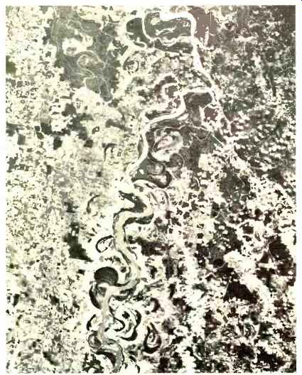
-------- An infrared photo of the Mississippi River and the surrounding
area taken from Apollo 9 spacecraft. Scientists can analyze such pictures
for land use, water distribution, and vegetation.
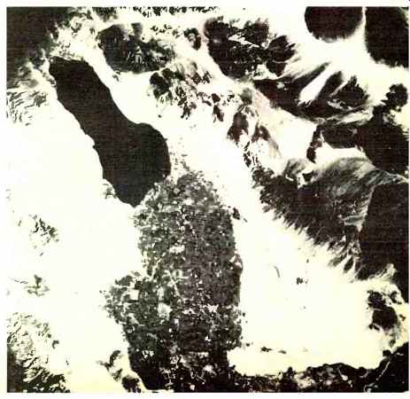
--------An infrared picture, originally in color, taken from Apollo
9 command module in earth orbit defines cropping patterns in the Imperial
Valley of California near the Salton Sea (black body at upper left).
ERTS will produce similar data of entire U.S.
The growing concern over ecology and the increasing problem of pollution have also stirred major interest in the potential of remote sensing by satellite to help detect and pinpoint pollution and its sources. Already, lower-resolution cameras in weather satellites have shown the discharge of effluent into the ocean from rivers and streams. More advanced earth resources satellites may be equipped with such instruments as spectrometers not only to spot air pollution, but also to analyze it qualitatively. In short, with its frequent coverage of the earth on a broad regional scale, ERTS will give pollution controllers a new way to look at both air and water pollution.
Oil and mineral exploration will also benefit from the broad coverage of the new satellites. Ground features normally associated with "finds" can be surveyed quickly by the satellite to narrow the areas of exploration, thus increasing yields and reducing cost of finding the resources. The same spectrometers used to monitor air pollution could enable future satellites to pinpoint certain gases, such as iodine, which frequently hang in invisible clouds over potential oil and mineral sources.
As numerous as they now appear, areas of application will no doubt expand even further once the data begins to flow in from the satellite. For example, after analyzing photographs taken from the Gemini and Apollo spacecraft, geographers feel they can chart population growth in major urban areas using the satellite pictures. ERTS thus may provide a means of taking an interim census from space.
Present plans for ERTS call for the first spacecraft to be launched in the first half of 1972 with a goal of one year's operation. At the end of this year, ERTS B will be sent into orbit to provide another year of experimental coverage. An ERTS C and D, which would carry relatively simple film photography systems, with the film being returned via a special re-entry vehicle, is under consideration.
Beyond the present experimental satellites, there are a host of possibilities. If ERTS A and B live up to expectations, an operational version could follow quickly. There could also be a number of special-purpose spacecraft, each configured to perform specific functions. For example, spacecraft zeroing in on oceanography could be outfitted with specialized instrumentation such as radar scatterometers.
In all cases, there will be broad participation in the program not only by non-NASA government agencies, such as the Departments of Interior and Agriculture, but also by private industry and universities as well. For example, some 25 to 30 companies-chiefly in mining and petroleum-have shown an interest in the program and may become users of the satellite data.
The satellite may very well acquire an international flavor. Although no formal policy has yet been expounded, President Nixon told the United Nations last year that data from earth resources satellites would be "open to the world community."
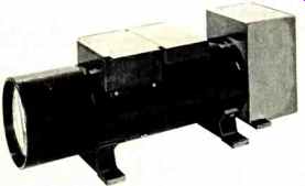
---- A model of the vidicon TV camera, three of which will be carried
aboard each satellite. Using 4200 horizontal scanning lines, this will
be the highest resolution TV system ever flown in space.